Build satellite-powered applications in minutes, not months.
Pull satellite data. Build your monitoring solution. Deploy it into your operations.
No procurement delays, no vendor dependency, no black box.
Backed By
You've been asked to deliver satellite-powered insights. Here's what happens next.
You know what you need. But patching together expert tools and juggling fragmented workflows across teams gets in the way.
GIS & Mapping Tools
You start with the maps.
You've got base layers, ground data, maybe even your own satellite feeds. But to go from maps to operational insights, you need analysis, models, and automation. GIS tools speak one language and data teams speak another. Bridging the two takes time and a lot of handoffs.
Python Notebooks
You switch to Jupyter.
Now you're in control: your data, your code, your model. It runs great in the notebook. But operations want a dashboard. Teams need to collaborate. Libraries clash. The model breaks outside your machine. What worked in dev stalls in deployment.
DevOps & Vendors
You loop in the dev team.
You're in queue for next quarter. Vendors quote $$ for a few sprints. It ships too late. By the time a solution arrives, the stakeholder's priorities have shifted. No one uses it. What's left is a black box no one can maintain or reuse.
One secure workspace.
From satellite data to board-ready intelligence.
LYRASENSE gives your team a single environment to ingest satellite data, run analysis, collaborate across functions, and deliver production-ready dashboards and reports. No GIS handoffs. No fragile notebooks. No vendor dependency. Your analysts own the workflow, and you own the outputs.
Trusted by innovators at:
All you need to go from first query to production
With LYRASENSE you gain complete control, without the complexity. From finding & fetching data to application deployment in the most seamless way.
Agentic AI at the Core
At the heart of LYRASENSE is the Geo Agentic Swarm™ — the system that handles everything from data ingestion to application deployment.
Why it matters:
You don’t need to juggle tools, teams, or tasks. What once took three separate workflows now happens seamlessly in one.
Define Area
Draw port boundaries
Search for Data
Query Sentinel, Landsat
Generating analysis code
Build Dashboard
Deploy interactive map
Template Library + Data Access
Why it matters:Petabytes of satellite data, pre-indexed by region and date, ready to use from day one. Pre-built analysis templates for vegetation health, emissions, infrastructure, water, and more. Start from a proven workflow instead of a blank page.

GHG Emissions Monitoring
Track greenhouse gas emissions and carbon footprint from facilities.
Try template →
Vessel Detection & Classification
Detect and classify maritime vessels using SAR and optical imagery.
Try template →
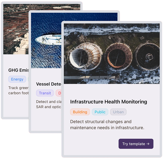
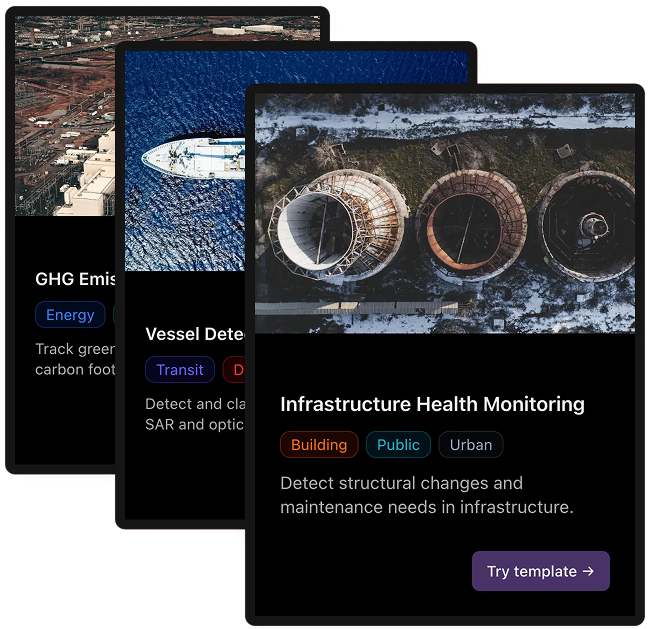
Infrastructure Health Monitoring
Detect structural changes and maintenance needs in infrastructure.
Try template →Collaborative Workspace + Notebook Agent
Why it matters:Share your workspace with collaborators, supervisors, or clients. The Notebook Agent understands your data and your question, so you always have an expert alongside you, even if you're working alone.
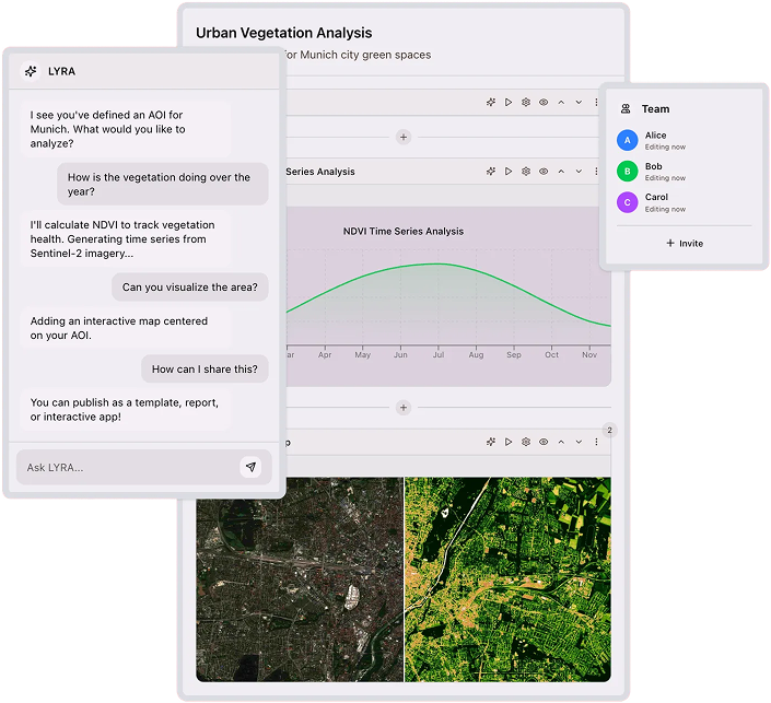
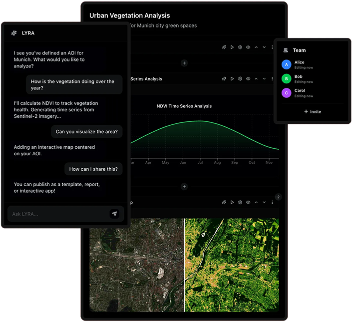
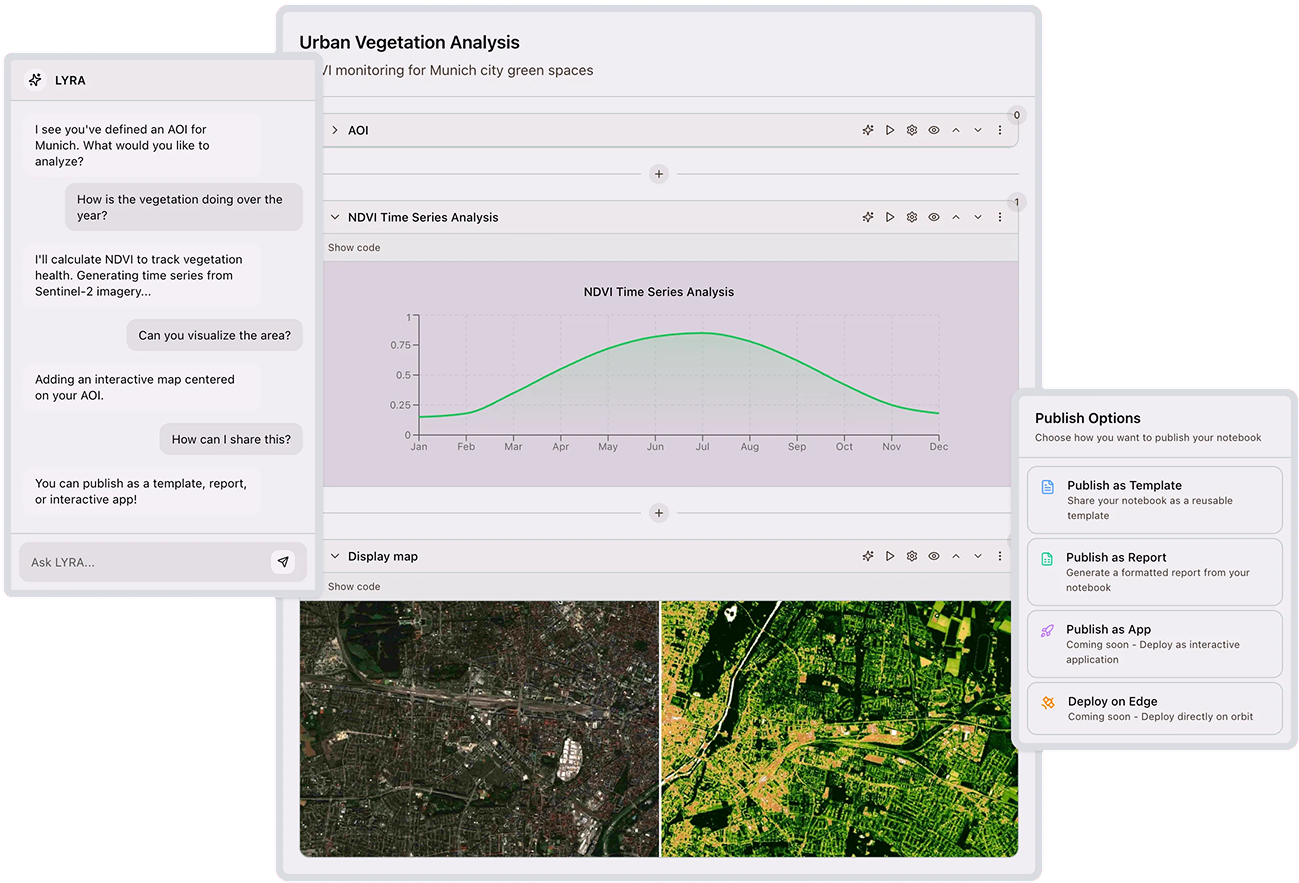
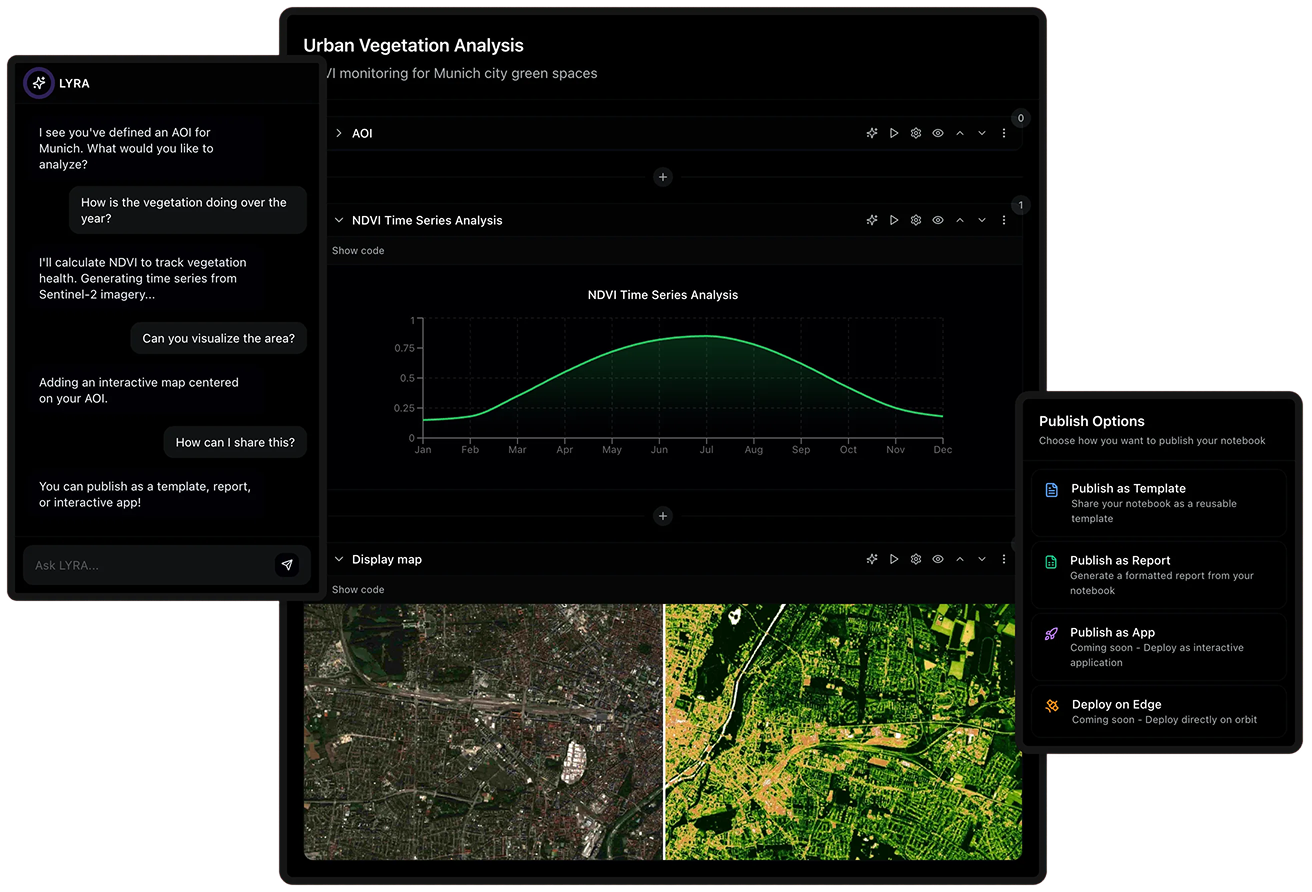
LYRA
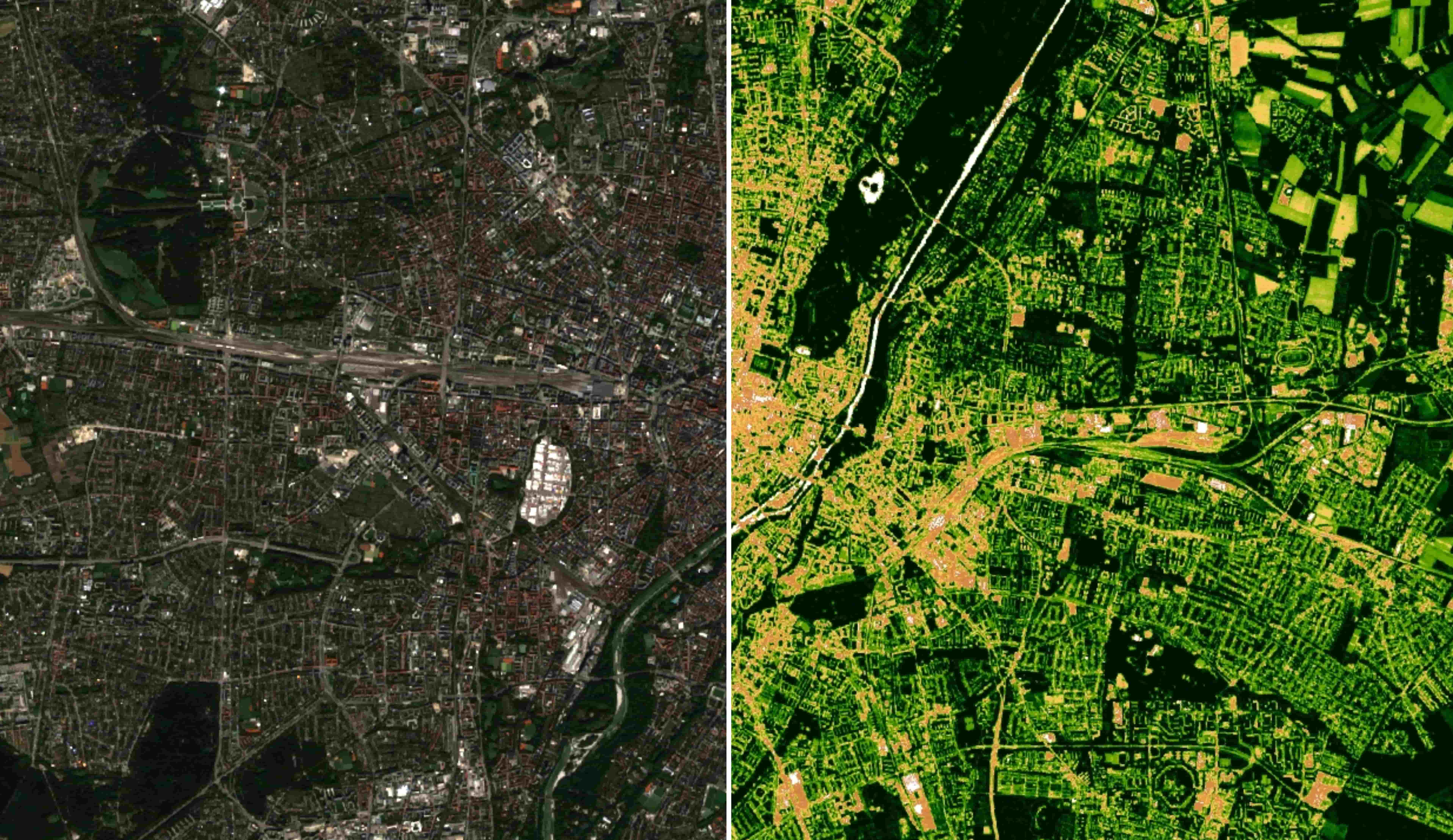
Urban Vegetation Analysis
NDVI monitoring for Munich city green spaces
Production-Ready Outputs by Default
Why it matters:Publish your results as an interactive map, a formatted report, or a shareable dashboard without leaving the workspace. Stakeholder-ready by default.
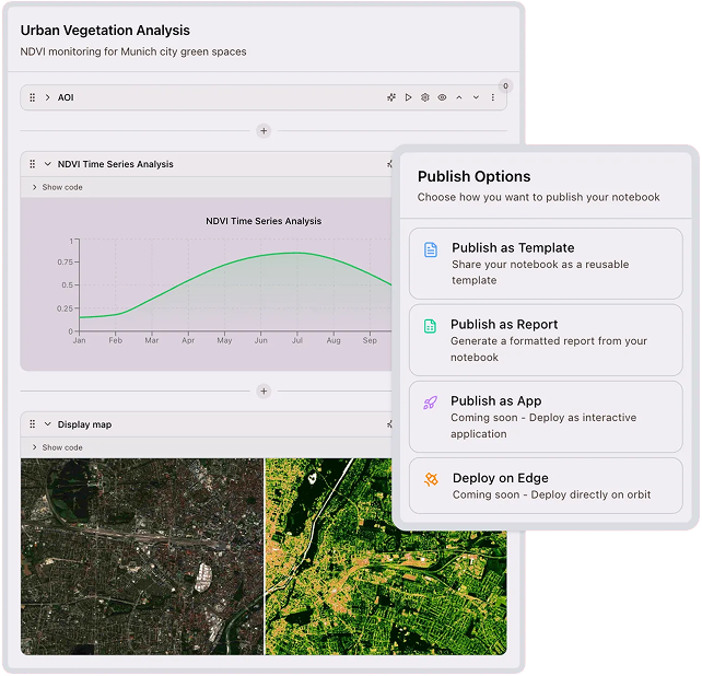
Urban Vegetation Analysis
NDVI monitoring for Munich city green spaces
Publish Options
Choose how you want to publish your notebook
Publish as Template
Share your notebook as a reusable template
Publish as Report
Generate a formatted report from your notebook
Publish as App
Coming soon - Deploy as interactive application
Deploy on Edge
Coming soon - Deploy directly on orbit
Start building today and get access to:
Data
Sensors
Templates
Built by the community
See what others are building
Explore templates and data apps built by data scientists. Customize and deploy from one collaborative workspace.

Agricultural Yield Prediction
Predict crop yields using satellite imagery and weather data analysis.
Try template →
Dry Bulk Commodity
Track global commodity shipments and storage levels from space.
Try template →
Route Planning Optimization
Optimize logistics routes using terrain and infrastructure analysis.
Try template →
Renewable Energy Site Analysis
Identify optimal locations for solar and wind installations.
Try template →Vessel Detection & Classification
Detect and classify maritime vessels using SAR and optical imagery.
Try template →
Port Activity Monitoring
Monitor port congestion and shipping activity in real-time.
Try template →
Solar Farm Performance Analytics
Analyze solar panel performance and detect maintenance needs.
Try template →
Urban Development Analysis
Track urban expansion and infrastructure development over time.
Try template →
General Mineral Detection
Identify mineral deposits using hyperspectral satellite analysis.
Try template →
Forest Coverage Assessment
Monitor deforestation and forest health with vegetation indices.
Try template →Infrastructure Health Monitoring
Detect structural changes and maintenance needs in infrastructure.
Try template →GHG Emissions Monitoring
Track greenhouse gas emissions and carbon footprint from facilities.
Try template →Built for and around our users
See what early adopters are saying
With @LYRASENSE I can cut my project time in half. Having everything in one place and integrated AI feels superhuman!
I loved testing @LYRASENSE and cannot wait for the official release! Integrating Earth Observation data into our product has been transformational.
This is mind blowing! I was always struggling with all the geospatial Python libs, now I can just have the AI do it for me! 🚀
I can finally focus on value-adding work and not spend over 60% of my time figuring out how to get the data I need and where to run my experiments!
I never thought coding could be that easy! The @LYRASENSE Geo-AI is crazy, and I can even talk to it in my language! 🤯
It's crazy how much faster I can build with this, and the fact that non-coders and developers can collaborate effortlessly is next level!
This is the future! With prompts in my native language I was able to build code that actual senior developers were able to work with!
I can really see the value @LYRASENSE will give us! We will finally have the ability to build in-house solutions with full control over the process!
Trusted by 30+ experts across energy, mining and telecom
Backed by
Common questions
Build the capability. Own it permanently.
Request a live demo with your use case. We'll show you what your team could be delivering, on your data, in your sector, this quarter.